Mobility is a precursor to community living and engagement and is a critical equity issue. Teams from the UW Makeability Lab and the UW Taskar Center for Accessible Technology have worked to develop and deploy tools like AccessMaps, OpenSidewalks, and Project Sidewalk that are transforming how we share, evaluate, and understand our urban environments. Researchers in the Makeability Lab are also addressing indoor safety risks.
Early childhood access to mobility
Joint research with UW iLabs has demonstrated that early childhood access to mobility technology is also a critical asset for development and learning. Continuing studies in the IMPACT Collaboratory, Neuromechanics & Mobility Lab, and the AMP Lab are measuring device usage and are forging new understanding of the significant benefits of mobility tools, such as ride-on cars, on key childhood development. measurements including cognition, behavior, vocalization, and even expressions of delight. Further work examines how caregivers’ expectations and training, environmental conditions, and access to therapeutic mobility tools can affect adoption and the benefits of therapeutic devices.
Learn more in Early Access and the Brain Research.
Sidewalk accessibility for Washington state
The 2026 OpenThePaths Conference, organized by CREATE associate director Anat Caspi, hosted discussions among policymakers, city planners, disability advocates, and technology professionals about OS-CONNECT, Washington State’s first map of pedestrian infrastructure.
In a recent podcast, What It Would Take to Map Every Sidewalk in Your State, Caspi spoke about the need for and reach of OS-CONNECT and the conference. She also shared how her late daughter, Aviv, helped inspire her work, the tool named in Aviv’s honor, and the importance of ethical, human-centered, and anti-ableist AI.
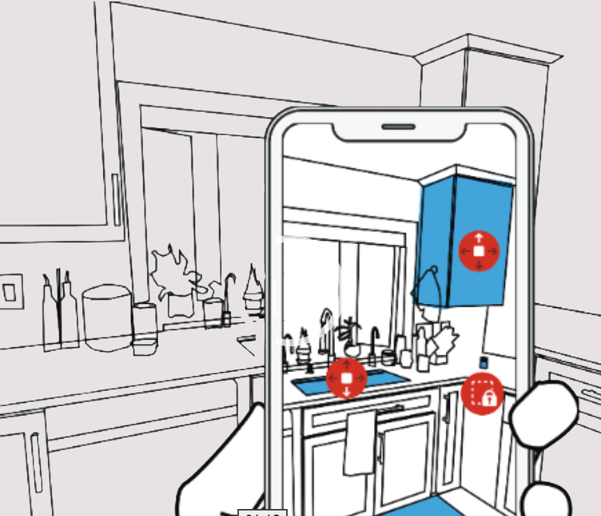
RASSAR – Room Accessibility and Safety Scan in Augmented Reality
RASSAR is a novel smartphone-based prototype for semi-automatically identifying, categorizing, and localizing indoor accessibility and safety issues. With RASSAR, the user holds out their phone and scans a space. The tool uses LiDAR and camera data, real-time machine learning, and AR to construct a real-time model of the 3D scene, attempts to identify and classify known accessibility and safety issues, and visualizes potential problems overlaid in AR.
RASSAR researchers envision the tool as an aid in the building and validation of new construction, planning renovations, or updating homes for health concerns, or for telehealth home visits with occupational therapists.
CREATE leadership: Associate Director Jon Froehlich (Paul G. Allen School of Computer Science & Engineering)
Augmented Reality to Support Accessibility
CREATE students Xia Su and Jae Lee, advised by CREATE Associate Director Jon Froehlich in the Makeability Lab, discuss their work using augmented reality to support accessibility. The Allen School Ph.D. students are presenting their work at ASSETS and UIST this year.
- Read the UW News article
Open Sidewalks
Every form of travel uses pedestrian infrastructure in some way. The final segment, after parking a car, locking up bicycle or exiting the bus, ends up being a walk or wheel to the destination. Features like steep hills, sidewalks, uneven surfaces, and crossing street traffic impact pedestrian mobility. However such information is hardly known or collected, and none in the form of a transportation network.
The OpenSidewalks project attempts to address this problem by suggesting standardized, transportation network-focused methods for gathering detailed information such as sidewalks, curb cuts, crossings, and street furniture through community engagement and crowdsourcing. The OpenSidewalks project also seeks to ensure data consistency and longevity through the use of OpenStreetMap, open standards and open technology.
CREATE leadership: Anat Caspi (Paul G. Allen School of Computer Science & Engineering)
Project Sidewalk
For individuals with a mobility disability, sidewalks play a crucial role in independence, quality of life, and overall physical activity. However, unlike their road counterparts, there is a lack of high-quality sidewalk datasets and fast, inexpensive, and reliable sidewalk assessment techniques. This limits how sidewalks and sidewalk accessibility can be studied in cities.
Project Sidewalk explores a two-fold vision: first, to develop reliable, inexpensive, and fast hybrid human+machine learning techniques capable of mapping and assessing every sidewalk in the world — an ambitious goal that we have been working on since 2013 — and second, to leverage this data to enable new pedestrian-oriented mapping tools, to support advocacy and government accountability, and to enable new urban analytics pursuits not previously possible.
CREATE leadership: Associate Director Jon Froehlich (Paul G. Allen School of Computer Science & Engineering)
RELATED RESEARCH NEWS
Articles on indoor and outdoor mobility research at CREATE.
Taskar project helps pedestrians find accessible routes all over Washington state
April 9, 2025 AccessMap is an app and a collection of data sets that let pedestrians tailor routes for their accessibility needs and preferences. Coverage has been spreading across Washington state and now includes a new data set, called OS-CONNECT, for sidewalks and other paths statewide, from Forks on the Olympic Peninsula to Clarkston in…
Kim Ingraham — engineering assistive robotic devices for people with disabilities

March 25, 2025 CREATE faculty member Kim Ingraham designs personalized, adaptive control strategies for assistive robotic devices, such as exoskeletons and powered wheelchairs for people with disabilities. Her work aims to optimize and customize the technologies by making sure humans are in the device control and feedback loop. “Historically we have studied the way humans…
Winter 2023 CREATE Research Showcase
At the December 2023 CREATE Research Showcase, students from CSE 493 and other CREATE researchers shared their work with faculty, students, and community partners.
Off to the Park: A Geospatial Investigation of Adapted Ride-on Car Usage
November 7, 2023 Adapted ride-on cars (ROC) are an affordable, power mobility training tool for young children with disabilities. But weather and adequate drive space create barriers to families' adoption of their ROC. CREATE Ph.D. student Mia E. Hoffman is the lead author on a paper that investigates the relationship between the built environment and…
Augmented Reality to Support Accessibility
October 25, 2023 RASSAR – Room Accessibility and Safety Scan in Augmented Reality – is a novel smartphone-based prototype for semi-automatically identifying, categorizing, and localizing indoor accessibility and safety issues. With RASSAR, the user holds out their phone and scans a space. The tool uses LiDAR and camera data, real-time machine learning, and AR to…